


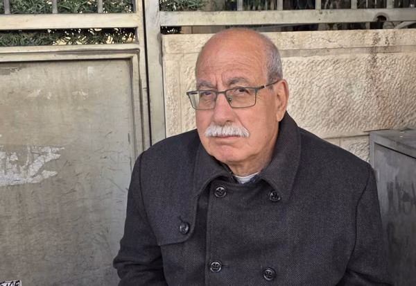
The expert in settlement affairs, Khalil Tafakji, described Qalandia Road as a silent killer of geographical contiguity, aiming to define the borders and contiguity of the desired Palestinian state and eliminate this possibility.
He explained that the plan for this road is old and new, as the military order for it was issued in 1983 under number 50 for roads, which stipulates the establishment of longitudinal and transverse roads in the heart of the West Bank, with the aim of embodying and achieving an infrastructure on the ground that serves the settlements in the heart of Jerusalem and its surroundings, and at the same time achieving the goal of dividing the West Bank longitudinally and transversely, to facilitate security and military control over it.
Tafakji pointed out that this road plan was objected to at the time, leading to its freezing, then it was brought up again during the arrival of the Palestinian National Authority in the nineties, within the framework of discussing what was called the plan to revive this project, which resulted in what is known as Road No. 9, which starts from Baqa al-Gharbiyya in the Palestinian interior towards the Palestinian Jordan Valley area, and was called "Trans-Samaria" and is linked to Road 45, which passes through Kafr Qasim and penetrates the West Bank to the Jordan Valley.
This plan had been frozen until September of last year, when it was approved with a strategic goal of establishing the Atarot settlement with 9,000 settlement units, in order to link this settlement with settlements located outside the racist wall, such as "Migron", "Kochav Yaakov" and "Beit El" settlements, in addition to separating the infrastructure, especially the West Bank roads from the settlement roads. This, according to the occupation's planning, leads to rapid traffic for Israeli settlers without checkpoints or impediments within what they call Greater Jerusalem in the Israeli concept, which is equivalent to 10% of the West Bank's area.
Tafakji considered that Qalandia Road, which is six thousand kilometers long, devours the lands of Qalandia, Al-Ram, and Jaba, and tunnels are spread along it to connect it with the ring road that encircles Jerusalem, including tunnels to connect the Gush Etzion settlements in the south, and the ongoing accelerated implementation of what has become known as the "Sovereignty" road, which touches the areas of Al-Eizariya, Abu Dis, and Eastern Sawahreh, with the aim of isolating Palestinian communities through Palestinian infrastructures that differ from the settlers' infrastructures, completely isolating Palestinian towns from the settlements that devour everything in their path..?!
Tafakji concluded that Qalandia Road or Road 45 is an intensive expression of expanding Israeli settlement to impose a fait accompli and achieve the dream of Greater Jerusalem and create a complete separation process and prevent geographical contiguity between Palestinian and Israeli towns.

شارك برأيك
Khalil Tafakji to "Al-Quds": Qalandia Road, a silent killer of the Palestinian state and a declaration of war on it