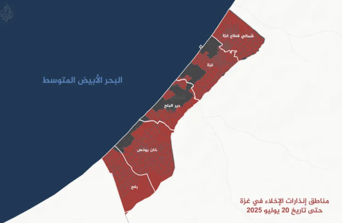


Approximately 82.4% of the Gaza Strip has become a hazardous area, while the remaining 17.6% is home to nearly two million displaced Palestinians, according to a data map prepared by Al Jazeera's Sanad News Verification Agency.
Recent map developments indicate that the warnings have included the Kissufim axis, which separates Deir al-Balah from Khan Yunis. The area between the two cities has become a danger to displaced persons, while the coastal Rashid Street remains the only road connecting the central and southern governorates and has not yet been classified as a danger zone.
The process of narrowing safe zones and confining hundreds of thousands of people to limited areas coincides with the worsening famine disaster caused by the lack of sufficient aid, coupled with inadequate distribution methods that do not guarantee its access to all displaced persons north and south of the Gaza Valley.
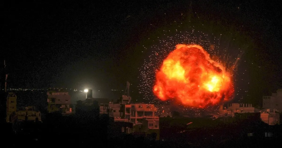
According to a data analysis conducted by Al Jazeera, Israeli evacuation orders peaked last April, with the complete evacuation of Rafah and the Israeli army's announcement of the start of a military operation codenamed "Gideon's Wagons," which displaced hundreds of thousands of residents of Beit Hanoun, Beit Lahia, Sheikh Zayed, Tel al-Zaatar, Jabalia, and the al-Tuffah and al-Shuja'iyya neighborhoods in eastern Gaza. Later, evacuation orders extended to include large areas of Deir al-Balah and most of Khan Yunis, with the exception of some parts of the al-Mawasi area.
Sanad Agency analyzed satellite imagery, along with a collection of evacuation warnings issued by the Israeli military between March 18 and July 20, 2025, and plotted them on a single map based on the block numbers contained in those warnings. These are divisions the Israeli military has adopted since the start of its operations in Gaza on October 7, 2023.
Evacuation of 300 square kilometers
The analysis results showed that the area covered by evacuation warnings amounted to approximately 300.6 square kilometers, representing 82.4% of the Gaza Strip's total area of 364.8 square kilometers, compared to a narrow, scattered area of no more than 17.6%, with an area estimated at 64.2 square kilometers, which is considered the last resort for the displaced.
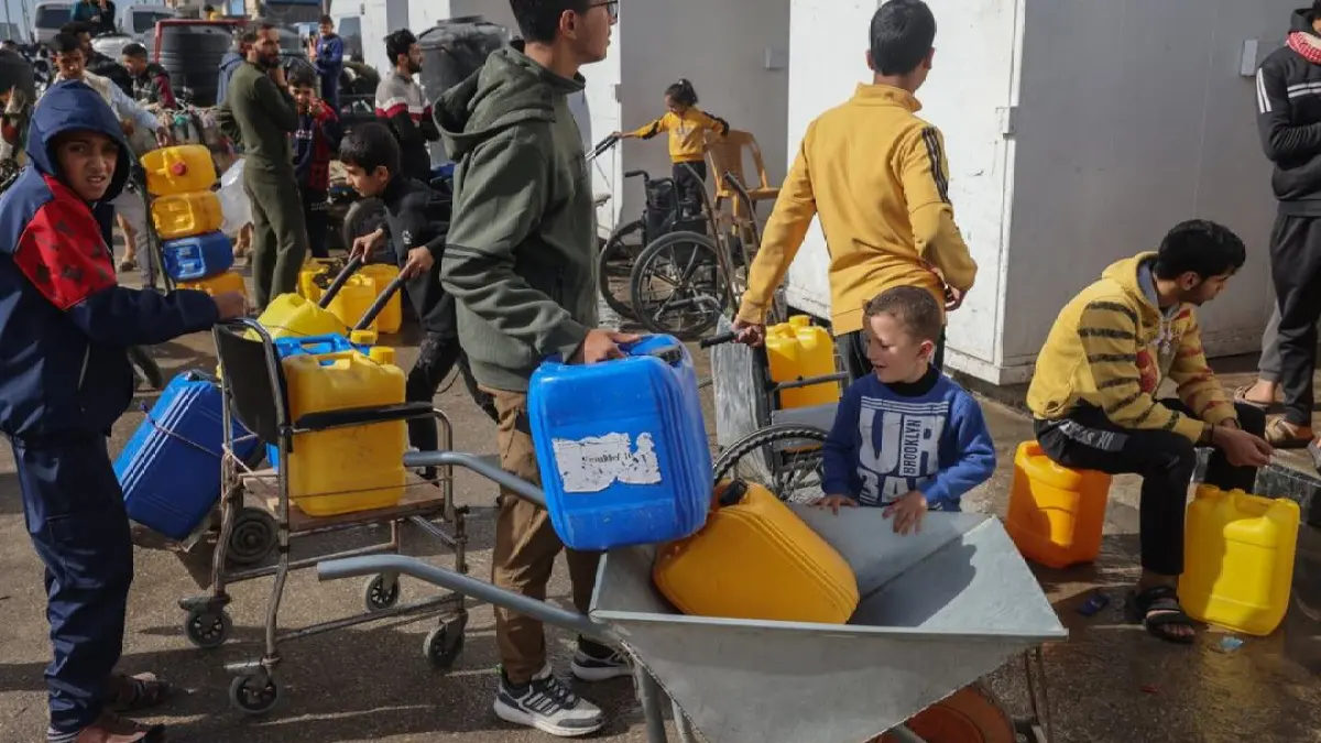
Over the past 48 hours, the Israeli army issued evacuation warnings for 9 blocks in the Deir al-Balah area, namely Blocks 130, 132, 133, 134, 136, 137, 138, 139, and 2351.
According to satellite images taken yesterday, Sunday, July 20, these areas are densely populated with displaced people's tents, with a combined area of approximately 5.6 square kilometers.
Despite the Israeli military's orders for displaced persons in Deir al-Balah to move south to the Mawasi area, areas considered safe in Khan Yunis have become extremely limited and overcrowded with displaced persons who have flocked to the area over the past months as a result of Israeli operations.
Commenting on the latest eviction orders in Deir al-Balah, the United Nations Relief and Works Agency for Palestine Refugees (UNRWA) said that Israeli authorities had issued further forced displacement orders to families who had previously been displaced repeatedly. In a post on the X platform, it asked, "Where will they go this time?"
UNRWA added, "The bombing continues, and there is no safe place in Gaza. People are starving and cannot find food. Aid must be allowed to enter on a large scale and be distributed safely. UNRWA must be allowed to do its work. The ceasefire must be now."
**Interior** Satellite images show the overcrowding and suffering of displaced people in front of the US aid point.
crowds of food seekers
Other photos obtained by Sanad Agency show the tragic scene of crowds of displaced people searching for food at US aid points in the southern Gaza Strip.
Satellite images taken on July 13 show a large crowd of displaced people streaming from their tents in the Mawasi area of Khan Yunis and Deir al-Balah toward the US aid point located in the "Shakoush" area of Rafah, near Khan Yunis.
Image analysis reveals the Israeli military's complete control over the area, while displaced people wait for the gate to open to receive aid. Thousands of displaced people gather among the sand dunes at at least three locations in an area known locally as "Al-Jura," a sand pit used by displaced people to seek shelter from Israeli army fire, often staying there for hours.
Separating the crowds from the aid point are a number of Israeli vehicles, which surround the area with fire and completely control it. Another military post and buildings surrounding the aid point are fortified by the army, including snipers, according to eyewitnesses.
Image analysis indicates that displaced people walk at least 1.5 kilometers from the last vehicle-free zone to the aid point, which translates to a journey of approximately 3 kilometers each way. The ordeal doesn't stop there, as people arrive 12-24 hours in advance, under the scorching sun, in an attempt to secure the aid they need due to the large numbers of people waiting.
Journalist Muhannad Qashta, a displaced person from Rafah who has documented the events in the US aid zone on numerous occasions, pointed to the extent of the chaos resulting from the disorganization of thousands of people and the lack of precise and announced opening times for the aid points run by the US-based Gaza Humanitarian Foundation.
He explained that the area known as "Al-Jura" has become a death knell for the displaced, as they are subjected to heavy fire from Israeli military vehicles positioned opposite their locations, despite their attempts to seek cover from the fire.
Qashta reviewed satellite images for this report and noted that the number of people around the aid point was many times greater than what was shown in the images.
He said the displaced people's journey begins by staying or sleeping near the aid point, then moving to a vehicle stop, then sneaking into the Al-Joura area to wait for the gate to open. The waiting period is long, and they are then allowed to reach the point, but most of them do not receive food due to the insufficient quantities available for thousands of people.
On July 14, Palestinian activists posted a video showing Israeli vehicles firing heavy rounds of bullets at aid seekers who were gathering in the al-Joura area, preparing to reach the aid distribution point in Rafah. Sanad verified the video and found it to be recent, dating back to July 12, in the same area where the satellite images were taken.
Two days ago, the Government Media Office announced that 877 civilians had lost their lives in what it called "death traps—US-Israeli aid centers." More than 5,666 citizens had been injured, while 42 others remained missing.


Share your opinion
The occupation is isolating two million Palestinians in 17% of Gaza's area.